| | | |
The "Bad Neighborhood" (wink wink) Scoring System

Sidestepping Overt Racism With Chicken Restaurant Mapping
| | | | |
Eskimos have less words for snow than Americans have for areas of our country where the population is, let's say; more at risk for sickle cell anemia: 'Urban', 'Inner City', 'Ghetto', 'Skid Row', 'The Hood', 'Detroit', 'Blighted', 'Slum', 'Low Income', 'Depressed', 'Underprivileged', 'Watermelontown'. That last one may or may not be from my 92 year old great aunt who lived in the same neighborhood since 1955; but in 1970, in her words, "went to fucking shit because of that watermelon-loving cocksucker LBJ". And she may or may not have used a different word than "watermelon". Her vintage phrasing aside, Aunt Virginia raises a good point. Since President Johnson did blurr those red lines, how's someone to know where the 'Inner City' (wink wink) ends and the good part of town begins? In 2025 you're a click away from real-time traffic, terrain, weather and satellite maps; but nobody's developed one that plots melanin levels. I'm joking. While such a map is technically possible; its unconscionable. Unless of course done by someone with a lot of melanin in which case it would unconconscionable if everyone didn't celebrate it. Imagine if my redheaded ass used even an unbiased source such as census data to build a system to score an address based on its surrounding ethnic composition. That would be so wrong. However...
| | | |
"Urban"(wink wink) Area Indicator

Popeye's Chicken Headquarters Score:
Score Your Address:
| | | | |
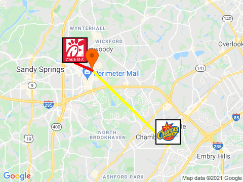
...Suppose you could achieve the same outcome without resulting to measuring that which dare not be measured? You could relieve your conscience of recognizing its preconcieved notions while simutaneously reaping the benefits of those preconceived notions. That's some intellectually dishonest plausabile deniablity we can all get behind--no matter if standardized academic testing is biased for or against you. Win-win-win. I realized you don't have to directly measure how many not-susceptible-to-malaria people are in an area, you can get there by proxy. You can gauge the "ghettoishness" (wink wink) of an address by how close it is to 2 fast food chicken restaurants. Ever see a Chick-Fil-a in "the hood" (wink wink)? Or a Church's Chicken that wasn't? Of course not. They both know their figurative and literal place in this world and build their restaurants accordingly. So, I devised an algorithm that takes the closest Church's and closest Chick-Fil-a to an address and computes a score from -10 to +10 assigning how "blighted" (wink wink) that address is by its proximity to the two. The closer to Chick-Fil-A the better, the closer to Church's the more "poverty stricken" (wink wink).
| | | |
How "Ghetto"(wink wink) Are U.S. Landmarks?
| | | | |
Now remember, as with all pages of my site; the big take away from all of this is that I'm a horrible person. It's not Chik-Fil-a's fault for doing actual economic and demographic research and building their restaurants in well to do areas. It's not Church's for doing the same but in "under privileged" (wink wink) areas. Nor is it politicians for allowing the disparity between areas to exist, continue and widen. And its heresy to even think it could be the people themselves.
This whole thing is 100% on me for noticing it.
|